
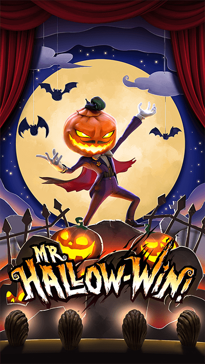
Mr. Hallow-Win
\n“Trick or Treat!” The children sang happily as they knocked on the door.\nThe moon shined wanly in the dark sky while a gentle breeze blew by, carrying the children’s laughter as they all wandered on the streets carrying Jack-O-Lanterns in their small hands. The children were all dressed in various scary and spooky costumes, going from house to house trick or treating happily.\nAmong these busy houses that were welcoming knocks every few minutes, there on the hillside, stood an old decrepit looking house covered in vines. The house itself was silent and exuded a strange and eerie atmosphere that scared all the children away.\nThere was a story that was known amongst the children, that in this abandoned looking house, lived a man called Mr. Hallow-Win, who love to play games. Legend has it, that if you visit that house on Halloween night, you will be challenged to a puzzle game by Mr. Hallow-Win himself! They say that if you win Mr. Hallow-Win’s challenge, you will be awarded generously. However, should you lose the challenge, you will be trapped in the house forever!\nDo not fear the ghosts that haunts the house, for the Mini Haunt Feature guarantees players with a win! Let the scary looking Jack-O-Lanterns decorated around the house to entertain you with rewards during free spins as well.\nOn this spooky Halloween night, are you brave enough to trick or treat at Mr. Hallow-Win’s door? Will you be the one that finally defeats his challenge and win the legendary mystery prize?\n
Name
Mr. Hallow-Win
Game Type
Video Slots, 3D Games
Full Size
15.3 MB
Initial Download
15.3 MB
Compatible with

iOS

Android

Windows

Mac OS

HTML5
Language

English

Chinese Simplified

Thai

Chinese Traditional

Indonesian

Korean

Russian

Japanese

Vietnamese

German

Swedish

Spanish

Italian

Danish

Dutch

Finnish

French

Norwegian

Polish

Portuguese

Romanian

Turkish


Copyright fortune mouse Rights Reserved.
 English